
The International Geographical Congress in Paris 1875.
Research and comments by Jørgen Malling Christensen.
Illustrations by Sverre Avnskog.
Browsing French newspapers and catalogues from the 1870s, I found evidence that Rasmus Malling-Hansens unique cartographic map projections were exhibited at the International Geography Congress in Paris, that took place August 1 to 10, 1875.
Participation was by nations, not by individuals, and Denmark, as well as Sweden and Norway, each sent a delegation and several exhibition items. In Denmark, the Ministry of Education, Culture and Ecclesiastical Affairs (in Danish: Kultusministeriet) was the responsible authority for Denmarks participation. The organizing committee was headed by a famous teacher and geographer, professor Edvard Erslev, 1824-1892.
Erslev was a prolific publisher of geography books, some for schools and universities, others for the general public. In 1876 he took the initiative to establish the Royal Danish Geographical Society, at which he served for many years as a society secretary and editor of the Danish Journal of Geography a journal that is still thriving and important. The website of the Royal Danish Geographical Society www.rdgs.dk provides a link to browsing and downloading all issues of their Journal.
The Ministry appointed Erslev organizer of the Danish delegation and participation in the International Geography Congress in 1875 the second such congress ever held. In the Danish Daily Fædrelandet, issue of May 24, 1875, Erslev publicly invited interested parties to submit geographical works and items to him in preparation for the congress.
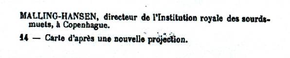
Apparently, Rasmus Malling-Hansen submitted an example of his uniquely designed world maps, and his contribution was included in the Danish exhibition. On page 74 of the Exhibition catalogue, we read:
MALLING-HANSEN, directeur de lInstitution des sourds-muets, à Copenhague
14 Carte daprès une nouvelle projection.
- Notisen om Rasmus Malling-Hansen i katalogen over utstillingen i 1875.
%EF%B9%94%22%3E%20%EF%BD%9C%20%3C%EA%A4%B7a%3E&md5=274574bbccecf83b594c6e4415d018c6.html)
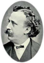
- Bertel Christian Budtz Müller, 1837-1884, Danish pharmacist, who ventured into photography at an early stage and became a much sought-after portrait photographer in Copenhagen.
%EF%B9%94%22%3E%20%EF%BD%9C%20%3C%EA%A4%B7a%3E&md5=052a8837fceebbd2eac43f72c6f80aa6.html)
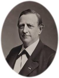
- Edvard Erslev, 1824-1892, famous teacher, geographer and professor. Photo: DKB.
%EF%B9%94%22%3E%20%EF%BD%9C%20%3C%EA%A4%B7a%3E&md5=2ece0053f35b010fd79a9b1175861107.html)
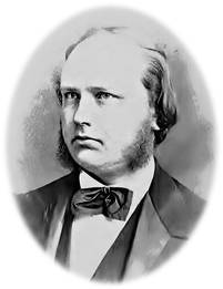
- Rasmus Malling-Hansen, 1835-1890, principal, priest, inventor and scientific researcher.
%EF%B9%94%22%3E%20%EF%BD%9C%20%3C%EA%A4%B7a%3E&md5=df5c72aa414883fb0d15478088663e88.html)
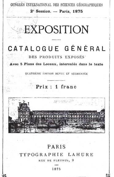
- The front page of the catalogue of The International Geographical Congress in Paris 1875.
i%CC%88%C2%B9_%22%3E%20i%CC%88%C2%BD_%20%3Ce%CC%82%C2%A4%C2%B7a%3E&md5=a2e5db039e_dc87a099927dce17.html)
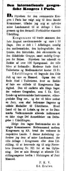
- In the Danish Daily Fædrelandet, issue of May 24, 1875, Erslev publicly invited interested parties to submit geographical works and items to him in preparation for the congress.
%EF%B9%94%22%3E%20%EF%BD%9C%20%3C%EA%A4%B7a%3E&md5=e0d02aeb4e943c14d882411edb770034.html)
- The actual issue of "Fædrelandet" from 1875.05.24.
%EF%B9%94%22%3E%20%EF%BD%9C%20%3C%EA%A4%B7a%3E&md5=36e713252ccdf9_06c62d930539356b.html)
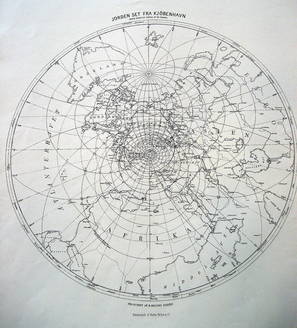
We assume that Malling-Hansen had developed his global map projections as part of his research into the correlation between solar heat and the growth of children. Altogether, we know of six different maps of this special Malling-Hansen projection, and they are all kept in the map archive of the Royal Danish Library in Copenhagen.
There is a map for each of these cities: Copenhagen, Paris, Athens, St.Petersburg, Stockholm and Rome. Each of the maps depict the globe in its special way and has the title: The Earth as seen from Paris (or any other of the cities) until an angle of 80 degrees.
Below each map projection is stated: Projiceret af R.Malling Hansen, i.e. Map projection by RMH, and: Fotolitografi af Budtz Müller & Co (photo lithograph by B.M. & Co).
Bertel Christian Budtz Müller, 1837-1884, was a Danish pharmacist, who ventured into photography at an early stage and became a much sought-after portrait photographer in Copenhagen. His studio was at 21, Bredgade, close to the Royal Palace Amalienborg, and he was by appointment photographer to the royal Danish, Norwegian and Swedish courts.
It must have been expensive for Malling-Hansen to use his services, and this is an indication of his strong motivation to have his innovative maps printed and shown in public.
Unfortunately, none of the maps are dated, but at the archive of the Royal Library, the item cards suggest the year as 1875, and that tallies very well with the fact that we now know, that at least one of the maps were handed over to Edvard Erslew shortly after May 24 and selected to participate in the Paris exhibition and congress in August that year.
What is very interesting and intriguing here, is that these map projections pre-date the period of Malling-Hansens research into the weight and growth processes of his pupils!
Malling-Hansen started his long series of weighing and measuring the children in 1877. So, what prompted his early interest in carthography taking it so far as to develop his own very unique projections? To my mind, it indicates that he had ideas and notions about the importance of solar heat and solar light for biological growth processes long before the astonishing results of his measurements emerged!
However, this is conjecture; and the fact, that the Malling-Hansen map projections are so different and enigmatic, make it more difficult to draw conclusions. Only when we understand the intended message and information inherent in the 6 known map projection, will we be able to fully grasp their importance and their link to Malling-Hansens physiological research.
His main scientific work is Periods in Childrens Growth and in the Heat of the Sun (only in Danish and German), published in 1886, and it does not contain any information about the significance of the map projections. This seems to suggest that his initial enthusiasm for the carthographic projections waned over the years. But it could also be, that he simply did not have enough time and energy to finish his research before his early demise in 1890.
Whatever the case, at least we now have documentary evidence that Malling-Hansen participated with a map projection at the International Geographical Congress in Paris in 1875. Several of the Danish contributions received medals or honorable mentions from the organizers, but Malling-Hansen was not among them.
I have searched Danish newspapers during the time period in question May to December 1875 but found very few and insignificant references to the Paris congress. I have also searched Malling-Hansens letters, but there are very few, as yet found, from this time period, and none of them contain any references to the maps or to the congress in 1875.
However, another interesting research track must be followed up: The Royal Library has a file with letters to and from Edvard Erslev, and it is my hope that Rasmus Malling-Hansen and Erslev corresponded in connection with the congress arrangements.
- Earth seen from Copenhagen.
%EF%B9%94%22%3E%20%EF%BD%9C%20%3C%EA%A4%B7a%3E&md5=abe6970464a64c2c84b784e8011ee833.html)
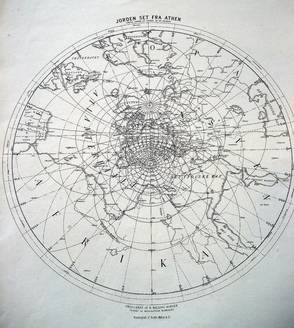
- Earth seen from Athens. All photos: Jørgen Malling Christensen.
%EF%B9%94%22%3E%20%EF%BD%9C%20%3C%EA%A4%B7a%3E&md5=e5ab35acaa866fe87d6d41767aa9e881.html)
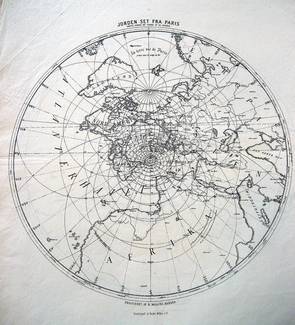
- Earth seen from Paris.
%EF%B9%94%22%3E%20%EF%BD%9C%20%3C%EA%A4%B7a%3E&md5=9edd6456013ec441df5c70483b376fea.html)
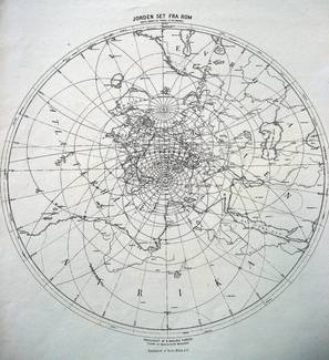
- Earth seen from Rome. All photos: Jørgen Malling Christensen.
%EF%B9%94%22%3E%20%EF%BD%9C%20%3C%EA%A4%B7a%3E&md5=5f74119ea2b9959fc8a4672633964409.html)
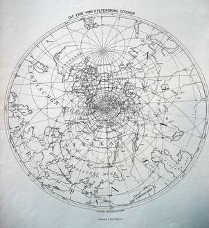
- Earth seen from St. Petersburg.
%EF%B9%94%22%3E%20%EF%BD%9C%20%3C%EA%A4%B7a%3E&md5=4da7b27007eb7aacc131fb8f2ad9350a.html)
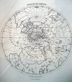
- Earth seen from Stockholm. All photos: Jørgen Malling Christensen.
%EF%B9%94%22%3E%20%EF%BD%9C%20%3C%EA%A4%B7a%3E&md5=bc20123414b0e883eec95100d2c6f9b5.html)
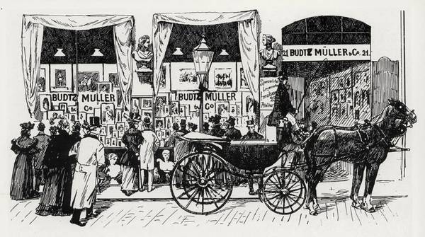
- An old drawing of Budtz Müller's fotographic studio in Bredegade 21, Copenhagen.
%EF%B9%94%22%3E%20%EF%BD%9C%20%3C%EA%A4%B7a%3E&md5=d4fc47f9d995711c44303101a7b4bc7d.html)
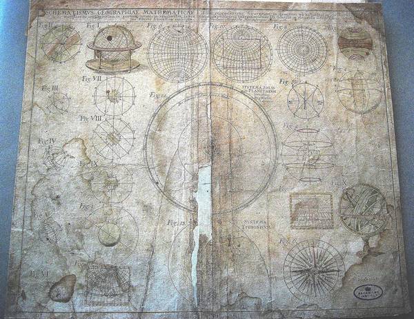
- This ancient map is placed in a box together with the six Malling-Hansen map projections. They belong to the map collection of the Royal Library, Copenhagen. There were no more items in the box, and that makes me assume that Malling-Hansen kept the old map together with his own cartographic projections. Sometime after his death, these and other documents from his office were handed over to the library, and as I believe still kept together. The old map has a Latin text and is clearly intended as a learning and instructional tool. If memory serves me right, it was printed in 1738. My assumption is that Malling-Hansen used it as a guideline and inspiration in order to construct his own highly original and unique cartographic projections. We know that Malling-Hansen never hesitated to venture into new learning, skills and challenges. He was, undoubtedly, a person that kept on self-educating himself throughout his life. Thus, during his relatively short lifespan he learned and mastered many skills and areas of knowledge, e.g. education for the deaf, theology, music (skilled singer, piano and organ player), languages (German, Latin, Greek, some Hebrew, probably some French, Volapyk), metallurgic machine technology, cartography, science, hygiene, nutrition, architecture, treatment of stammers. I think he was driven by an insatiable curiosity, experiencing a whirlwind of ideas, coupled with high ambitions and most certainly all of this on a foundation of solid confidence, that he would be able to learn and master whatever he set his mind to.
%EF%B9%94%22%3E%20%EF%BD%9C%20%3C%EA%A4%B7a%3E&md5=859cb81bfa714641b15f903bdfad951c.html)